An Inaccurate Map

All right- I’ve been dodging around this point for a while by working on areas that are relatively isolated, but as I move into Office Complex and some of the back areas of Questionable Ethics, it becomes much moreobvious that we’re going to need some sort of coherent map of Black Mesa in order to figure out what connects to what.

We have a map that .RK made by putting together birds-eye views of every Black Mesa level, but it reveals the entire game to be a non-Euclidean mess that’s
nigh-impossible to connect in a sensible manner (plus, the discontinuities created by Apprehension and multiplayer maps split Black Mesa into several “chunks” that can’t be fully organized). I’m planning to make something that has less to do with the actual distances and
angles between areas than it does with what looks like it should be accessible from what and how the entire base is layed out- how Black Mesa is meant to work, basically. While I’ll certainly be using .RK’s map as information on what is nearby what, I’ll also be giving the preference to names on signs, similar architecture, and locations visible from other maps.

I can’t make the other pre-disaster mappers, or mappers in general, work off of thisdesign- it’d be awesome if you did, but you’re free to ignore it, makechanges, or even make your own attempt at organizing the facility.

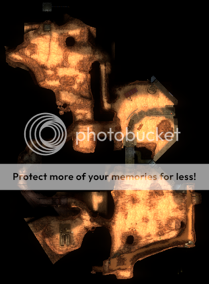
At the moment, the Black Mesa Research Facility looks like this:

Full-resolution image

ODG File It Was Made From

Right out of the gate, we can conclude that dm_stalkyard is its own thing- looking at the climate, the sounds of traffic, and the map description from multiplayer, it’s a satellite complex far, far away from the main facility. Looking at the map’s ambient weather, speculating that the facility is near a major port, and keeping our location confined to the general vicinity of the American Southwest, I’m going to say that it’s located in an industrial part of San Francisco. All that really matters, though, is that Stalkyard is not here.

I figure the best place to start on the actual complex would be with the surface- that’s two dimensions of freedom to manage instead of three, and the underground sections twist and turn in on themselves so impossibly that I’m feeling perfectly qualified to “unravel” them any way I please. And, since it’s a large, obvious landmark that the base would probably be built around, I’m going to start with the buildings around the Black Mesa airstrip:


This is going to turn into an absolute bitch to work on as an image, so let’s render it a bit more pictorially:

Now, the area that most obviously abuts the airstrip proper is bm_c2a5h- the hangar you find the guard in and the big gasworks place (I think that might actually be an on-site aviation fuel refinery, but I really have no idea):

Fortunately for us, Black Mesa was kind enough to give many of the surface buildings alphanumeric designators, allowing us to relatively easily slot the complex into the wider map:


(The Lambda Complex is through “ACC55” (was someone trying to spell “access”???), the yellow building with the guard tower (blue hexagon) on top of it, opposite the hangar.)

We can do basically the same thing with bm_c2a5g:


Going off of their locations in the skybox, the entire area is oriented somewhat like this:

However, I think it would be a good idea to move things around a little so that the right-side bunker in H map is BG7N, and things fit together like so:


Then, that road behind the ambush garage could take a tunnel through the “radar tower” building, and become the road that leads through/into B55.

Sadly, it’s about here that our ability to use the airport as a reference point dries up, and we can’t propagate back any further through Surface Tension. We’ll have to look elsewhere for our evidence.

The map at this point looks like so:


Recalling the general structure of the terrain until now, it’s actually pretty easy to imagine the Facility just kind of snaking its way up the side of that big mountain up at the top of the map.

Looking at the “main” section of Surface Tension, we can use the numbered buildings to figure out where the different maps are in relation to each other. The large tower “A10” is a good starting landmark, so let’s begin with the map bm_c2a5e, where it first appears:

Buildings A3 and A5 turn out to be the main structures explored in bm_c2a5f, so we can simply “patch” that map onto this one:

By putting these two areas together, we are able to ID a number of buildings we missed before, and establish a more complete picture of the area:


However, we’re still not ready to attach this section to the airport area just yet. We can look at the tunnel leading to the carpark to see where it might go (positioned so that the ammo dump is above the ambush garage, with the yellow concrete bunker areas between them) but there’s still a lot of things to consider.

For instance, I for one am very curious about what that long, low, extremely well-ventilated concrete structure at the top of the map could possibly be. At first I thought it was some kind of super-heavy-duty security wall surrounding this section, but there are additional buildings outside of it.

Cool beans so far. And indeed, out of all the areas where Black Mesa’s geometry offends physics, Surface Tension is by far the worst offender. Sure, Inbound and We’ve Got Hostiles overlap as well but it’s such a simple fix (making a hallway turn left instead of right and/or vice versa), but affecting the same changes with ST is much more difficult since you have skyboxes to worry about (especially sunlight, which will have a definite effect on map lighting) plus the unique geometry, especially since you would have to employ that trick some number of times in order to resolve the discrepancies. You’d definitely have to make changes up through the A map from where you’re at right now.

There was a point where I actually considered modding that out, creating versions of the maps that don’t overlap, but obviously that’s a fair amount of work for little gain. Whoever ends up taking ST for pre-disaster might also consider releasing post-disaster versions as well that have these fixes to the geometry.

(On an aside note, I will make an updated version of the overhead map eventually. I can’t ass myself to do it right now but I probably should.)

When making the STU stuff, we only really worried about how it fit together internally, and were only worried about it loosely, focussing more on making everything look good. For the skybox, Brian made most of the models, including the beautiful mountains and ground (which are all a single model). Spencer (who is also a pilot) put together the entire airstrip and ground textures. And then I made it fit all together internally and I worked with Shawn to generate the skybox models of the G and H map. I don’t know if anyone actually noticed but you can see H from G and vice versa (which was an absolute shitload of work to get right, I can tell you that, and it basically required us to turn 2 entire maps into a skybox model).

As RK said, Surface Tension is the biggest mess spatially in terms of all our chapters. You’re gonna have a tough time fitting it all together. While putting the maps together we cared a lot about really obvious spatial contradictions that most players would notice (for example, early versions of C2A5D did not have that weird 180 snake in the road when you encounter the LAV, thus making it so you doubled back on yourself almost immediately and very noticeably in a way that doesn’t work).

I noticed one minor mistake in your fitting all the STU stuff together - your assumption about bunker BG7N. Though it’s a minor detail, it doesn’t fit together the way you have it on the map. BG7N is connected to H’s radar tower bunker, like so:

It’s one, huge ass bunker. There’s then a small gap between that and H’s cinderblock buildings C5 and C6, but you can never actually see that in game. As with my mod version of STU, the retail STU actually has you following an entire single road the whole way to the Lambda Bunker, with a few detours of course.

You’ll notice there’s a weird overlap and height discrepancy between G and H where the bunker is intersecting itself - disregard that. It’s meant to be one thing. The heights don’t line up in game like they should because I made them inconsistent on purpose. When left as they should be (spatially consistent), you couldn’t really see H from G or G from H. So in G, I lowered H’s skybox model, and on H I heightened G’s skybox model. Just in the name of giving the player a better view. But the road on H’s street battle is meant to be at the same height as the road leaving G’s helipad.

Also, no love for I? That map, and by extension, the Lambda Bunker, actually slot in nicely too. When doing the skybox stuff I spent quite some time reorienting the map and the transition to make it fit. The Garg arena sits nicely behind the blue hangar in G.

We’ve got a good thing going with forward- and back-propagating the dense, building-heavy central area of Surface Tension, so for the time being let’s just keep doing that.


bm_c2a5d doesn’t have Building A10 in it, but it does have the same power-lines-and-radar-dome-on-a-ridge skybox and connects reasonably directly to the conjoined bm_c2a5e/f. A number of things even synch up relatively nicely if we do that:

Unfortunately, this results in some pretty serious problems when the cliff gets involved. If we go off of its actual location, it’ll end up inside of the munitions dump, and that just makes no sense whatsoever. To make matters worse, acocrding to .RK’s map (which has the same rotational alignment as ours) that cliff actually faces east- and most of the facility is east of the hatch leading to it!

Ok. To get a better sense of how the entire complex is layed out, let’s take a look at another “chunk” of it- bm_c2a5i and bm_c3a1b, collectively our only real look at the area around the Lambda Complex.

There’s… really not a lot here to go on in terms of linking up areas, but if we put them where they would go in the “real” (i.e. non-Euclidean) map, we would get something like this:
Unfortunately, this doesn’t make a great deal of sense- the G and H maps create this whole giant complex of buildings to the southeast, but bm_c3a1b has this huge open plain there…

All right.

Having had a slow day at work to think it over, I’ve come to the conclusion that we are looking at the problem of constructing a working topside for Black Mesa somewhat backwards. There is absolutely no way the individual maps of the facility will fit together on the small scale- they’re just too confused and non-Euclidean, and if we disallow that then we end up with too many variables as maps can go basically anywhere. So instead, let’s try to construct a large, general plan for the format of the base, and see where we can put all of the maps inside of that.

Now, there are three very large parts of the base that establish its outer limits: the cliff in bm_c2a5c, the large industrial complex in dm_gasworks, and the airstrip in bm_c2a5g/h.

Let’s talk about the cliff first.


According to .RK’s map it faces east, and while it sure does look like there’s a lot of stuff behind it, there seems to be precious little on the plain in front- I only see three objects of any real note.

These antennas don’t really look like they’re attached to anything, and they’re very distant across this mostly-empty plain. As a result, I don’t think these are really associated with any major facility structures, nor are there any major facility structures between them and the cliff itself- and for that matter, we never see towers of this design anywhere in the Facility up close. They might be part of a perimeter system that wards off aircraft well before they can reach the Facility proper, or sensitive scientific instruments that need to be kept far away in order to work properly. Heck, they might not be a part of Black Mesa at all, just radio/cell towers for nearby towns. The one with the big satellite dish might be dm_stack, since from inside that map you can’t see anything around it, but I don’t think so- a satellite transmitter wouldn’t need to be isolated, and the BM Communications Division would I imagine be more centrally located.


There’s a facility just like this visible in Forget About Freeman, but I very much doubt that the two are actually the same: the one in FAF didn’t have the river or the road that leads to the landing bay, and this one doesn’t have the bunker complex or radar domes that surround the one in FAF. This is probably a service and logistics station where equipment and personnel to maintain the antennas are stored and routed, maybe also where aircraft to intercept intruders on the perimeter are deployed from.


Finally, this looks like a pretty damn good candidate for a facility entrance- possibly this road also serves the remote station up above, but given the distance I somehow doubt it. Not sure why the far side goes back underground when there’s just that big empty plain to cross, but maybe there’s another tunnel exiting from that little hill that we just can’t see…

Overall, I’m pretty comfortable saying that this cliff is the eastern border of the Black Mesa complex. That in and of itself gives us one bound on the facility’s structure, but there is another one that is not so obvious: while a protruding section of cliff face very effectively screens the north side of the map, we can clearly see a good long ways to the south and observe that there really isn’t a lot there. That means that while this area could indeed be on the southern end of the facility and not block anything, if the airstrip from c2a5h or the big jumble of industrial buildings from gasworks aren’t relatively far to the west, this cliff is probably on the north end of the base.

Oh, and rendered pictographically it looks something like this:

The other Big Map for determining the boundaries of the BMRF (aside from the airstrip, which I’m already pretty sure is the southern border) is dm_gasworks.

Now, it’s not immediately obvious how this map is even oriented- there’s no landmarks visible from other maps, and no sun. However, if we assume that the two maps are “set” at roughly the same time, we can use the moon in the night parts of On A Rail:


I don’t particularly like this arrangement, since the river visible from the cliffside flows northward and the river in gasworks flows southward. They might not be the same river, but I know that I’m already going to have to pull that trick in order to make the dam work and I don’t want to overuse it. So I’m going to ignore the rotation I just established and instead assume that these maps are not set at the same time, and flip Gasworks. I think the best way to do that would be to orient it so that the large outcropping near the gasworks facility is the same mountain/mesa/clifftop thing that the majority of the BMRF is on top of- that means the Gasworks River runs across the north end of the facility to join up at an offscreen confluence with the cliffside river, and Gasworks is the BMRF’s northeastern border:

Hell, that little “bob” in the rocks near the bottom left could very well be the rocky protrusion on the north end of the cliffside map!

As a side note, initially I thought that the alphanumerics on the gasworks buildings might have something to do with the area letters on the cinder block buildings in most of Surface Tension- however, they are in fact just designators for the buildings themselves. with the letter referring to the building and the number to the entrance:

The map refers to these buildings by their NATO phonetic alphabet letters, to avoid confusion.

Okay, I need to just say this about the map’s accuracy: OF COURSE IT’S INACCURATE! Making a map that is to tell you what the place looks like on the outside (or what the main layout of the facility is) is not technically possible. Gordon Freeman, Barney Calhoun and Adrian Shepard probably explored a fraction of the facility, and that’s three games! I would bet that the actual look of the map would be quite different and the models used in far away are there because the facility is that grand in size that it takes that much of the New Mexican Desert. The research done by the scientists is one of the things that show how much goes into making this facility because (forgive my swearing) it’s fucking HUGE. The joke of the facility I want to say is it’s size since this makes the most sense as to why Half Life was so long. It’s so immense that it took Gordon Freeman days/weeks to get to the Lambda team. The map is without a doubt inaccurate and you’re right on that. However, you would need to make more of the facility which you don’t see to fit in the missing puzzle pieces.

I don’t know why people inflate the scale of Black Mesa to such ridiculous levels, when going off of what we see in the game it’s not actually that large- I remember calculating that .RK’s 100% accurate map gives the entire facility an area roughly 50% of Wright-Patterson Air Force Base, a real-world installation about two hours away from me. All of Black Mesa takes place over the course of about a day and a half.

Furthermore, while it might not be a majority of the facility (although I wouldn’t rule that out), the fact that their maps “collide” or nearly “collide” several times indicates that between the four of them Half-Life, Opposing Force, Blue Shift, and Decay do cover a good chunk of it. I will, of course, be leaving areas blank to add things from other restorable mods later on- in fact, I kind of have to, since there’s nowhere near enough area in the existing maps to fill up my expanded outline both on the surface and underground.

Ironically, “how-it-should-be” Black Mesa is shaping up to be somewhat larger than the actual dimensions of the game world, since I’m moving areas apart that used to overlap.

We’ve got a lot of pieces to the Black Mesa puzzle set up, but there’s still a big one missing- the dam and its environs. The real map puts it roughly in the middle of the facility as far as east and west go, which makes a fair bit of sense, but it also puts it kind of ridiculously far south, near where the airstrip should be.

On its own, there’s not a whole lot to the dam, but in context it’s actually a very interesting area of the complex. The road up north of it terminates at Questionable Ethics, while to the south it goes into a bunker complex that looks similar to the one in Forget About Freeman. However, what’s more interesting to me are these buildings in the background:


They’re of a very unique design, and there’s exactly three other maps where that design appears:


The undertow ones look sort of different, but considering the fact that all three areas are residue-processing related I am guessing they are all in mostly the same place. In fact, building out and around from the dam proper…


Assuming the buildings we see in Residue Processing are the same ones as visible on the river canyon wall (and, indeed, while only one is visible, it is located in the same orientation), weird things happen: RP connects to Questionable Ethics on its south end, and QE is on the dam’s north side, but the canyon-wall buildings are about in the center. I think the best option is to go with a relatively tight rearrangement that breaks off RP’s C map at the long conveyor tunnel with the smashy plates and moves it elsewhere, possibly to the northeast somewhere so that moving in a generally westerly direction through QE still takes you back to the dam. Then, the main buildings of RP can nest nicely between the QE access road and the dam outflow river.


Undertow can then go even farther to the east, so that the large canal on the far side drains into the dam’s outflow river.


dm_bounce can then go… pretty much anywhere, actually, since it’s all in that deep ravine and doesn’t really have many identifying features visible. Since there’s power lines through it, though, I’m guessing it’s somewhere to the East (the sun is no damn help in orienting the map, as it’s almost directly overhead).

This… works, but I don’t particularly like it. I’d like to flip Bounce and Gasworks around (making them morning instead of evening and vice versa), move them to each other’s positions, and reposition the entire waste processing complex on the other side of the river. This requires an additional warp between Questionable Ethics’s maintenance tunnel and c2a4c, but at the same time it allows us to free up the space on the far side of the canyon for bm_c2a5b, moves the maps closer to the skybox elements (power lines and canyonside buildings) that can be seen from them, and perhaps most importantly allows us to make the tram rail that runs through Bounce the same rail that leads to the Biodome Platform hinted at in the very end of Questionable Ethics. There’s even a sensible numbering for the ‘B’ buildings- starting at the bottom with B01 in Undertow, looping around through Residue Processing (B map takes place in B2, A Map in B3, and C map in B5, and then coming back to Undertow with B5.
Unless someone can come up with a compelling reason otherwise, I think this is what I’ll be going for:

On a side note, I’m wondering if Apprehension might be near or even under Gasworks- not only are they both on the northwest corner of the facility, but the scientist at the end of Apprehension’s B map describes it as “the older, industrial part of the base” and if Gasworks isn’t old and industrial then I don’t really know what is.

You know, after having gone through a relatively complicated set of gymnastics to get it into place, I’m no longer sure if bm_c2a5b should go in its canonical location behind the dam. As structured, the area is actually backwards- the area labeled “maintenance”, which appears to have a rather large structure behind it, is what actually abuts the cliffside, while the road and more undeveloped parts face into the facility.


Now, I suppose that “maintenance” building could just be the last thing before the cliff (there’s some room, and in fact the cliff is going to be a ways north), but it just seems weird to me, especially since Questionable Ethics is this big exclusion zone with no roads really connecting to it and there’s a road heading out over the left side of the map to the facility edge that does not look like a facility entrance. So I’m just going to leave that map be for now and try to place the dam without it.

So, we have a Black Mesa Research Facility that currently looks like this:


And a dam that looks like this:

How do they fit together?

Despite .RK’s 100%-accurate map putting it on the extreme southern end of the facility and there being a map that connects it to the east-facing cliff, I think the dam would actually be best positioned somewhere to the north. That way, the river running past Gasworks can be the same one that runs over the dam (it follows a kind of twisty-turny path, but perhaps it was deliberately diverted?). In fact, this puts Questionable Ethics in a very sensible place- the road leading to it dead-ends because there is really no more facility after it, and not only does it have the same sector as Apprehension, which is nearby, but there is also the shark tank in common.

We’ve got a lot of the general structure of Black Mesa set up, but there’s a few things that still need to be taken care of to prevent them from causing trouble later on.

The first is the areas that we’ve already set up- the building-heavy “center” of Surface Tension, and Forget About Freeman. Going off of .RK’s map, the Surface Tension center proceeds in a generally easterly direction and then loops around to the north and starts going west in Forget About Freeman, terminating in the Lambda Complex. I think we can keep that arrangement pretty much the same here, with one slight change- In the actual map, the north-south separation between the two areas really is not that big, but at the same time there’s a very distinctive rocky landform with big white radar domes on top of it (I’m calling it Radar Ridge) that’s in the north of the main area skybox, and another extremely similar one in the south of the Forget About Freeman skybox:


So basically we would have something like this:
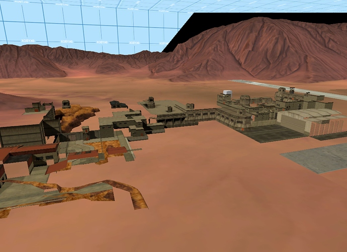
One thing that I might end up doing is moving the entire airfield-Lambda-ridge agglomeration back east a ways so that this heavily-developed area is more centrally-located… but other than that I am very happy with how this section is shaping up.

So I went ahead and moved the Lambda-Ridge-bunker agglomeration more east- I like it better having the Black Mesa Central Complex and Lambda facility more centrally located, although if this ends up conflicting with the expansion of the east end of the complex I might move it back, who knows. It’s also come to my attention that .RK’s map is sideways- geographic north is our west- but since everything is rotated it really doesn’t matter and I’ll just keep using the same directional system I’ve been using.

The other big area to look at is the western end of Black Mesa, with Blast Pit, WGH, and Office Complex in this big jumble down south and Sector C weirdly isolated up north. I tossed around a bunch of different ideas for this place, but nothing really ‘clicked’ the way it did when I placed the dam or built up the area surrounding Radar Ridge- with so much of Surface Tension and several of the topside multiplayer maps ending up on the east end (and taking relatively few underground areas with them), the underground topography is going to be a lot more important to the way that the west side operates.

We can already cross a few areas off our list- The biodome (Questionable Ethics, Opposing Force’s Vicarious Reality) is to the north across the river (seems to be the only part of the facility there- interesting), Apprehension (no idea what this area is properly called, if anything- the entire place is rather baffling) is to the northeast near Gasworks, the Lambda Complex is roughly in the center of the facility and the Black Mesa Central Complex is to its east (likely it was more properly “centered” before new construction expanded the facility to its present size):

I think we travel through much of the west or center-west side of the complex in Black Mesa Inbound, and it presents some very interesting areas:


We’ve got what we know to be the Level Three dormitories…


What looks like Area 3 Security spanning multiple sections…

This cinderblock-and-florescent-light area that just screams its kinship with Office Complex…


The Area 9 Transit Hub (could Power Up be under this? They’re in nearly the same place, and both have a lot to do with the transit system)…


And in the second map, this big industrial structure with a rocket in it. Perhaps this is up above Blast Pit??

The problem is, the actual map is a twisty, turny, confusy mess. Putting Office Complex behind the Area 9 Hub causes it to occupy the same “block” as this strange little area which really doesn’t look similar:


and the topside warehouse in WGH directly overlaps the observation area in the second map of Inbound.

My proposal is something like this. We start out with the Level 3 Dorms, Area 3 Security, and Sector D Admin areas in roughly their obvious locations (A3 stops at the second tram tunnel to turn off from the line the player takes, explaining its presence on both sides of the broad, 2-rail tunnel):

However, to deal with that weird little section of facility behind Sector D, I am proposing that we elongate the canonical section of track around it so that, while the facility certainly buts up against the HSSF, it has room enough to be its own thing.

This configuration does… interesting things to the other Inbound maps, which actually make it a lot easier to construct the rest of the east border of BM. I am imagining the underground section with the hub, security center and Office Complex being one tram-system “loop”, then another (larger?) loop that goes around the eastern edge of the facility (i.e. the eastern border) and connects to Sector C and the Biodome/Bounce rail system. The only problem is that internally, none of it makes sense.

Inbound’s B Map is almost completely dominated by this weird blue metal bunker thing:


When I look at them from the top down, however, they form this really strange pattern that doesn’t seem to connect properly:


(There is also a substantial vertical difference between the two wall sections, but since that just makes everything even more confusing I’m just not going to deal with it right now.)

Obviously this isn’t one large bunker, but I’ve tried a couple of different ways of rethinking this area, and neither of them really work either.

Could this be two separate bunkers? I doubt it- the one employing the second outdoor section’s wall would have to be extremely small in order not to push into the first section or collide with its implied east-extending wall.

Could this not really be a bunker complex at all, but just a very thick security barrier that we actually pass through? Again, I don’t think this makes a great deal of sense- for one thing, there’s still that weird ‘protrusion’ formed where the two wall sections meet; for another, these structures appear to have more thickness to them than simple security walls would need; and finally if this is a security barrier then why does part of the BM rail system duck outside of it only to immediately go back in- through an unsecured cave entrance, no less!

Originally I thought of heavily re-positioning the two portions of the map so that the two bunker walls more or less connected:

I don’t usually do these sort of major warps in areas that aren’t pipes or ventilation shafts, through, so I was also thinking of really elongating that cave to make either two bunkers or one really large one:

Really, the deciding factor between these two approaches is going to be We’ve Got Hostiles- if I go with the bottom option, there will be an awful lot of facility to the west of it, making it unlikely that the surface segment is a facility entrance. So… I suppose that’s where I’ll stop right now- do people think the surface segment of WGH makes sense as an entrance, or is it deep inside the complex?

Ok. Having looked over the maps, there are some good arguments against bm_c1a3c being an immediate facility entrance that have nothing to do with its placement relative to the two Inbound topside areas:


First of all, WGH actually goes on for a substantial ways beyond c1a3c- I can fudge this to a substantial degree as elevators make for good lateral warps, but the fact remains that there’s this rather large area of subterranean construction around the AC vents, with an entire elevator apparently dedicated to it. Since I always thought of the surface construction at Black Mesa extending some distance beyond the underground areas, this is a problem.
Second, there’s that one weird segment of curved roadway that doesn’t connect to the warehouse road system- one end of that road goes into a tunnel that points directly east, towards where the facility ends.

Based on these facts, I am thinking that while c1a3c might be a facility entrance in the sense that the road leading from it goes somewhere else that is not Black Mesa, I don’t think it’s right up against the perimeter with nothing but open desert beyond. That indicates that we will indeed be using the two-bunker model of the east end of Black Mesa:

Looking at this structure, we can actually begin to get a handle on how the rail system is set up- I’ll wager that the south end of the big cylindical tunnel (i.e. the one Freeman doesn’t go down at the end of bm_c0a0b) connects back with the rail line colored blue on the map (the one between the security station and Office Complex). Back up top, the system loops around to that big chamber with the freight robot, then goes past Sector C and reconnects with the tracks coming into the Level 3 Dorms.


As it stands the big freight area sort of collides with Sector D, so I think I’ll go back to my old playbook and substantially exaggerate the vertical distance of that tunnel to put that big tangle of tracks just above the dorms:

This design is particularly interesting in that the track forms a giant loop through the western side of the facility- might this in fact be the ‘Red Line’ alluded to on a number of location signs?

We can also figure out the locations of a few important underground areas from here- Anomalous Materials is to the north, Sector B is to its southwest, and the canals run south from there to Office Complex in Sector D (The canals are probably a basement logistics area that serves other labs up above them; they don’t take up that whole space just by themselves). Although considering that the elevator to the canals is on the east side of Office Complex, I might move the entire west half of the area closer in so that the canals can run more under Sector D.

That… just about covers the layout of the west end of Black Mesa- I might stick some other areas in it and there is still Blast Pit to place, but I think next update I’ll actually be able to unify this with the eastern/central segment.

It’s time to unify the eastern and western ends of Black Mesa! Considering that pretty much everything from the C1 maps is on the west side and pretty much everything from the C2 and C3 maps is on the east, it seems logical for the connection to be On A Rail’s tunnel system.

OAR itself is a kind of rectangular structure that is longer north-south than it is wide east-west, and there’s a door leading into the rocket launch silo with a lambda logo on it, so I am thinking the area is in fact nestled under or beside the Lambda Complex like so:


This also fits with the general placement of something like the Lambda-ward section of Radar Ridge (but not exactly like it) being to the south of the launch pad.

Since Power Up (aka the Area 9 Hub) sits just to the southeast of OAR (perhaps OAR is even part of the Hub), so we can put the east end of Black Mesa like so:

Now, this makes for a rather large distance between Apprehension and the HALF when in the game they are connected by just a short piece of railsystem, so I’m going to reposition the HALF above the Lambda Complex and bring Apprehension down to more or less meet up with it:

The cliff I am thinking can now go UNDER CenCom on the eastern side of the base near where the runway ends, and Gasworks can then be brought further down:


There’s still a few remaining maps to find homes for, and I may want to rescale Gasworks as I am fairly positive it is not in fact a third of the base, but I think this finally gives us a good idea of how, in the grand scheme of things, the BMRF is actually layed out!

Time to finish up our model of Black Mesa by finding a home for the various maps we’ve for one reason or another not yet included.

First up is Subtransit- it’s a small, indoor map with a lot of rails in it and vague similarities to WGH and OAR that supposedly feeds into the Lambda Complex, so I am thinking this is part of the Area 9 transit hub- possibly a basement area above Power Up but below the entrance we see in Inbound:

Next up is pretty much the entirety of Blast Pit, a very large chapter that in .RK’s real map dominates almost the entirety of the southwestern end of the base. I know that in the actual game it’s more to the east of Power Up, but we’ve got this big hole between the building-heavy parts of Surface Tension, the rocket factory, the airport, and Power Up which is one of the few places that massive silo can actually fit. Its hugeness (and the fact that it is vertically very tall) makes me disinclined to put it someplace where there is already a lot of underground construction, and I think it makes a lot of sense for the rocket propulsion labs to be near that one industrial building with a rocket in it from Inbound.

After that, things get a little more complicated, and I’ll be doing maps one at a time.

With that out of the way, we have a map that I’ve actually been looking forward to placing for a while now, but wasn’t able to until the rest of the east-west divide was solved- dm_stack. Now, originally I always thought it was one of the remote facilities visible from Cliffside since one of those has what appears to be a huge satellite dish sticking out of it, but looking at it in more detail there are a lot of elements that link it to the southwestern area of the main base:


There are other architectural motifs in the map that could place it in another location- Apprehension-style doors, Undertow-style wastewater pipes, and so forth, but it was this extremely unique texture that convinced me to center Stack in the southwest somewhere, as it only appears in one other place:


Now, Stack itself is sort of a small, blobby map whose main defining feature is the road running through it. Considering the angles of the sun, that roadway would seem to run north-south. Now, I sort of wanted the roadway to go through the tunnel and connect to the southwest helipad, but not only is Stack’s road oriented perpendicular to that but putting it there would also make it very far away from the security office that is its main reason for being in the southwest to begin with.

It think it’s best to set things up so that the road tunnel is running more or less parallel to the east side of the tram tunnel, with the building opposite the comm relay (which might actually just be another part of the comm relay) being over the guard station and both the road tunnel and the helipad tunnel meeting up inside that one big blue-metal bunker structure. Up on the north end, I am thinking that the roadway either turns or branches off to connect with that one closed tunnel in WGH’s C map:

Lambda Bunker is pretty much A map of Forget About Freeman- they aren’t exactly the same thing, but they’re so close I really am convinced that FaF is just the ‘canonical’ version of that map and a ‘real’ Lambda Bunker doesn’t actually exist in the BMRF.

Not quite sure where to put the missing Surface Tension map, bm_c2a5b, but I’m already looking for ‘holes’ that could be patched to provide foot or tram access to areas of the base that are currently hard to get to.

Placing dm_crossfire is going to be fun.

Founded in 2004, Leakfree.org became one of the first online communities dedicated to Valve’s Source engine development. It is more famously known for the formation of Black Mesa: Source under the 'Leakfree Modification Team' handle in September 2004.